Naypyidaw [Myanmar], March 28 (ANI): Six earthquakes jolted Myanmar on Friday, a statement by the National Center for Seismology said.
As per the NCS, the latest earthquake occurred at a depth of 10km, making it susceptible to aftershocks.
“EQ of M: 4.3, On: 28/03/2025 15:25:39 IST, Lat: 19.43 N, Long: 95.47 E, Depth: 10 Km, Location: Myanmar,” NCS stated in a post on X.
https://x.com/NCS_Earthquake/status/1905566647047561634
Another earthquake of 4.4 magnitude on the Richter Scale occurred at a shallow depth of 10km.
“EQ of M: 4.4, On: 28/03/2025 14:48:32 IST, Lat: 23.35 N, Long: 95.31 E, Depth: 10 Km, Location: Myanmar,” NCS said in a post on X.
https://x.com/NCS_Earthquake/status/1905553362004967696
Another earthquake of magnitude 4.9 occurred at a depth of 30km.
“EQ of M: 4.9, On: 28/03/2025 13:07:03 IST, Lat: 22.55 N, Long: 95.34 E, Depth: 30 Km, Location: Myanmar.”
https://x.com/NCS_Earthquake/status/1905532843360412105
NCS reported that an earthquake of magnitude 5.0 occurred in the region as a result of the aftershock of previous earthquakes.
“EQ of M: 5.0, On: 28/03/2025 12:57:53 IST, Lat: 22.97 N, Long: 95.56 E, Depth: 10 Km, Location: Myanmar,” NCS stated.
https://x.com/NCS_Earthquake/status/1905524920693793011
An earthquake of magnitude 7.0 occurred in the region at 12 pm, at a depth of 10km, as per NCS.
“EQ of M: 7.0, On: 28/03/2025 12:02:07 IST, Lat: 21.41 N, Long: 95.43 E, Depth: 10 Km, Location: Myanmar,” NCS stated on X.
https://x.com/NCS_Earthquake/status/1905510943599051262
Prior to this, a powerful earthquake of 7.2 magnitude rocked the region.
“EQ of M: 7.2, On: 28/03/2025 11:50:52 IST, Lat: 21.93 N, Long: 96.07 E, Depth: 10 Km, Location: Myanmar,” as per NCS.
https://x.com/NCS_Earthquake/status/1905507779189813586
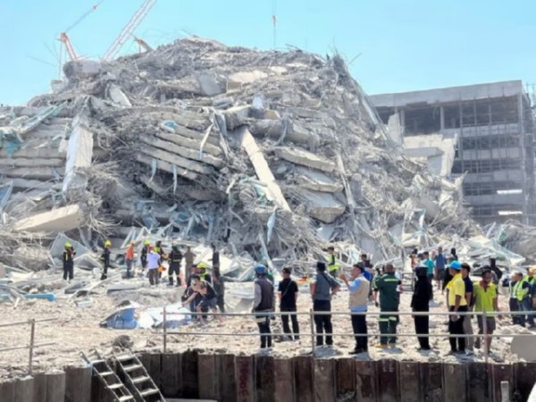
Shallow earthquakes like these are more dangerous than deeper ones due to their greater energy release closer to the Earth’s surface, causing stronger ground shaking and increased damage to structures and casualties, compared to deeper earthquakes, which lose energy as they travel to the surface.
Although Myanmar is an earthquake-prone country, an official national seismic hazard map has not been proposed.
Due to the collision between the Eurasian and Indo-Australian plates, Myanmar has a high seismic hazard level. According to the earthquake parameters summarized by the International Seismological Centre, around 140 events with magnitude greater than or equal to 3.0 have taken place in Myanmar and its vicinity every year from 1990 to 2019.Thus, it is evident that Myanmar is vulnerable to hazards from moderate and large magnitude earthquakes, including tsunami hazards along its long coastline.
The Sagaing Fault elevates the seismic hazard for Sagaing, Mandalay, Bago, and Yangon, which together represent 46 per cent of the population of Myanmar. Although Yangon is relatively far from the fault trace, it still suffers from significant risk due to its dense population. For instance, in 1903, an intensive earthquake with magnitude 7.0 that occurred in Bago also struck Yangon. (ANI)
Disclaimer: This story is auto-generated from a syndicated feed of ANI; only the image & headline may have been reworked by News Services Division of World News Network Inc Ltd and Palghar News and Pune News and World News

HINDI, MARATHI, GUJARATI, TAMIL, TELUGU, BENGALI, KANNADA, ORIYA, PUNJABI, URDU, MALAYALAM
For more details and packages